
How Tucker County Property Search Works
Start with the physical place. Then carry one stable key as you move between records. The WV Property Viewer accepts an E-911 address, parcel attributes, geometry, and coordinates. Its linked IAS assessment system offers Basic, Appraisal/Sales, Advanced, and Prior Ownership modes. Set the county selector to Tucker. That keeps an IAS search scoped to the county. The County Clerk's land-record page is a separate system. Its public landing page shows no search fields or word on how far its online deed index reaches.
- Search the address in the WV Property Viewer, or use only the road name in IAS if the number does not match.
- Open the parcel detail and note the district, map, parcel, suffix, owner display, community, and legal description.
- Use the deed book/page or party name to find the related instrument in the Tucker County Clerk index.
- Compare the assessment and tax sources by parcel ID and physical situs, not by mailing address alone.
- Ask the custodian about a courthouse terminal, copy, or record request when a needed entry is not online.
Tucker County Address Search Gaps
The E-911 search has strict rules. It expects a physical street address with city and state, and it excludes rural routes and post office boxes. IAS address values are separate and can be incomplete. That tool's guidance favors a street name. A complete address can still fail in one system even when the parcel sits on the county tax roll.
For a Tucker County property, start with the street name. Build a short list of matches. Compare the map, legal description, and parcel ID before trusting a single line. The physical address is the situs. The mailing address is for correspondence and may sit in another county. A Parsons, Thomas, or Davis ZIP label can reach nearby rural roads, so confirm community and boundary lines in the GIS map rather than treating the postal city as a deed fact.
Fields in Tucker County IAS
The IAS form pairs a basic set of fields with more detailed filters. Use only the fields that match your clue. Some option lists may not display every choice on screen. Confirm exact values in the live form.
| Field | Type | How it helps |
|---|---|---|
| Search Options | Mode tabs | Basic, Appraisal/Sales, Advanced, Prior Ownership |
| County, District | Dropdown | Scope the search to Tucker and a local district |
| Full Parcel ID | Text | Find a known parcel key |
| Owner Name | Text | Partial name; try LASTNAME FIRSTNAME |
| Street Name | Text | Prefer the road name when the full address misses |
| Map Number, Parcel, Sub-Parcel | Text | Search parcel segments |
| Property Class, Tax Class, Land Use | Dropdown | Narrow by assessment category or use |
| Min/Max Land, Building, Total Appr | Number ranges | Compare appraisal values |
| Min/Max Calc Acres, Deeded Acres | Number ranges | Filter by acreage |
| Sale From, Sale Through, Min/Max Price | Date and price | Filter recorded sale information |
| Flood Hazard | Dropdown | Advanced filter; choices were not rendered |
| Mailing Address, Legal Description | Text | Search owner correspondence or land description |
| Deed Book, Page | Text | Carry an assessment reference to the clerk |
| Building Year, Area, Structure Counts | Number ranges | Narrow by improvements and year built |
| Display Legal Description / GIS ID | Checkboxes | Add parcel identifiers to results |
The WV IAS property search exposes these search modes without a paid account. The clerk posts no fee or image schedule. Because of that, the assessment portal's access rules should not be assumed to govern recorded deed copies.
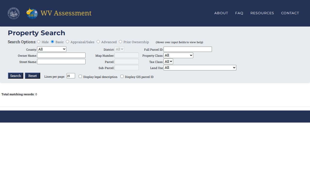
The IAS screen shows why a road name, an owner, and a parcel number belong in different fields. Each one belongs in its own field.
Tucker County Parcel ID Format
A full West Virginia parcel identifier combines district, map, parcel, and suffix segments. The Viewer pads each portion with leading zeroes, showing district as two digits and map, parcel, and suffix as four digits each; its example reads 01 2345-6789-0123. IAS may show a map value without that padding. Compare the segments, not the punctuation.
A known parcel number often beats an address. Keep the exact ID as the Viewer and assessment report display it. A lost leading zero can create a false mismatch. So can shifted punctuation. The ID locates an assessment parcel. The deed's legal description remains the cross-check for the land itself.
What Tucker County Results Show
A Tucker County assessment result can lead from a parcel to a public owner display. It also opens appraisal fields and a deed reference. The map panel adds community and location detail. The result row has limits. It may show one owner when several appear in the parcel record. A recent closing may not appear on the assessment roll yet. For a transfer, the newest recorded deed is the better check.
| Property Owner | Name shown on the assessment record; more owners may exist |
|---|---|
| Physical Address | Parcel situs; separate from the owner's mailing address |
| Parcel ID and GIS ID | District, map, parcel, suffix and map reference |
| Appraised and Cost Values | Land, building, and total appraisal fields where shown |
| Legal Description | Land description linked to the tax parcel |
| Sale Data | IAS Appraisal/Sales filters can search date and price |
| Map Context | Community, E-911 address, flood information, and delinquent status |
No result row or GIS line proves clear title, a surveyed boundary, or the full list of interests in land. Tucker County's viewer is a surface-property map. Mineral interests and county court splits may be missing. Use the record as an index into source offices, not as a certified conclusion.
Tucker County Search Result Limits
The WV Property Viewer caps searches at 1,000 records. Narrow it by district, map, or parcel. A broad owner name or street query can hit that limit fast. When a query returns too many rows, narrow by class or another known field. The Viewer exports a result set as CSV and displays a query URL plus the total match count, which helps you preserve how a search was run.
Hovering a result highlights it on the map. Click to zoom in and open basic parcel information. A record without valid geometry may be flagged. That flag signals a map issue, not a false assessment entry. Keep the parcel ID and search terms with any notes so a later check returns to the same record.
A street-name search can return a large set. Narrow with the district or a known map segment before exporting. CSV preserves the returned rows and fields. KMZ preserves selected map geometry. Neither export adds deed language or proves the visible boundary matches a surveyed line. Carry the parcel ID, query terms, and legal description together when sending a Tucker County result to the Clerk or Assessor.
Reading Tucker County Owner Names
Viewer guidance recommends the LASTNAME FIRSTNAME pattern. A partial name helps when initials, middle names, or spellings differ. The assessment system includes a Prior Ownership mode. Yet the local land-record index is still needed to verify transfers. A company, trust, or estate can appear as a grantee. An individual-name search alone may miss part of a chain.
For a parcel with multiple owners, open the detail panel. Compare it against the latest deed. Treat the displayed name as a lead, not a complete ownership roster. For an LLC, the Secretary of State's Business Organization Search can identify the entity filing. It also returns principal-office data. It still does not establish who owns the land.
Tucker County Address to Deed
IAS shows a deed book and page. Carry both values to the Tucker County Clerk. The clerk's public land-record page lists deeds, deeds of trust, liens, releases, plats, assignments, agreements, affidavits, and trustee reports. It publishes no search-field inventory or online date range. If the online index has no match, ask the clerk about a courthouse terminal, manual name search, or paper volume.
Once a deed is located, check its grantor, grantee, recording date, legal description, and any exceptions against the IAS parcel. A matching street name alone is weak evidence in older land records. Old deeds rarely follow modern addresses. A deed may cite a district, survey, watercourse, adjoining landowner, road, or lot reference instead. Such details often predate the current address system.
When Tucker County Search Fails
Use the office that keeps the missing record. The County Clerk sits at 211 First Street, Suite 205, Parsons. Land-record questions go to 304-478-2414 ext. 201. The Assessor is listed at 215 First Street, Suite 206, phone 304-478-3727. The public county page lists no fixed fee. Ask about certified and uncertified copies, page charges, and search fees before ordering.
West Virginia FOIA requests go directly to the custodian. Each request must describe the record with reasonable specificity. The response is due as soon as practicable and within five days, excluding weekends and legal holidays. Actual reproduction costs may be charged. A parcel ID, deed reference, party name, or date span gives the office a better start than a broad request for everything tied to a person.
Search Tucker County by Address or Parcel
Address search works best when the place is known. No parcel key is at hand in that case. Owner search builds a candidate list. Parcel search is most precise once the number is confirmed. Each method answers a different need. Addresses change, and assessment data can be incomplete. The three approaches may return different rows for the same Tucker County property.
| Search Key | Best For | Where It Works | Watch Out |
|---|---|---|---|
| Physical address | Locate a known site | WV Property Viewer E-911; IAS street name | Rural routes and PO boxes do not match E-911 |
| Owner name | Find candidate parcels tied to a name | IAS; clerk grantor/grantee index | Partial data, name variants, trusts, and multiple owners |
| Parcel number | Match one assessment parcel | IAS and WV Property Viewer | Formatting and leading zeroes can vary |
Not a title search. A Tucker County property search helps locate public records, but it does not prove that title is clear or that every interest is shown. Use the recorded deed and seek a title professional for a title opinion.